I’ll have to be honest, the concept of HGIS was a relatively foreign topic to me before December 2018. I had a good understanding of what HGIS was when this term started but had never had the opportunity to use it until these last few classes. I actually felt fairly confident on what I was doing when first launching the program. Being not very technologically savvy it did take me a few moments before I was informed I had to unzip the file before placing the datasets into the program. After I got around that I had no problems continuing on for a while before we had to export data. When I exported the new map file I tried to move on to the next stage with symbolizing attributed data. I ran into issues during layering properties, in the fields section while trying to change the number of classes to 4. Whenever I tried to change the number to 4 it would automatically change back to 1 and would not allow me to change the break values. After several minutes of being frustrated and wondering why I couldn’t get this section to work, I eventually had to get help. I was informed that I had exported data to the map incorrectly, I didn’t export all features. Once I was informed of my mistake I continued on as I had tried to earlier and was actually successful from there.
By the time I ended with Lesson 1, I was still not fully confident that I had done it correctly but continued on even so. By the last 3 minutes of class, I was more concerned with actually finishing the map and getting to an end result. In terms of labelling by the end, I cut a few corners as once again I really wanted to finish this lesson before the lab ended.
My start with lesson 3 was much more positive, I didn’t find it nearly as daunting as I felt with lesson 1. It also took me less time to start the program because I actually remembered to unzip the file before trying to put it into the program. The one place I had to stop to think was adding control points, as I wasn’t sure if I should click the wind erosion map first or the outline. After a few moments, I finally decided to click on something and figure out how it worked. I initially clicked the outline to the erosion map and realized I didn’t do it correctly and accidentally deleted the entire erosion map and had to re-do the entire thing. I went back through the process and re-started the process with the wind erosion map. I was surprised by how much I remembered American geography when having to add a control point at the northwest corner in Montana. From there I had no problems with the control points of the southwest corner of New Mexico, the northwest corner of North Dakota, and the northeast corner of Texas.
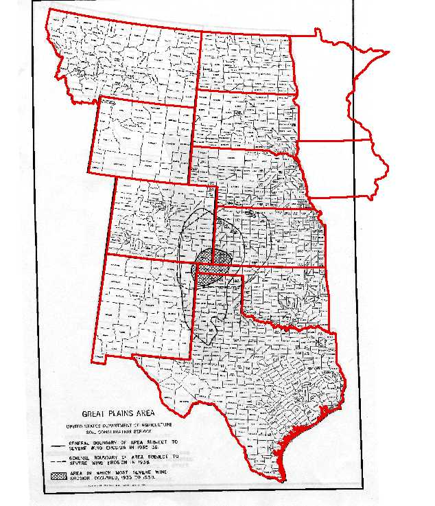
To be honest, I really didn’t understand the mathematical conversion as I really struggled with math throughout my entire life so I continued through the rest of the steps, ignoring the numbers. With the three other control points, I added ones at the southeast corner of Texas, on the border of North Dakota and South Dakota, and the north-west corner of Wyoming.
I looked back to the residual values in the link table and ended up deleting all of the ones I had placed as they had the highest offset in the table. I believe I ended the process with geo-referencing there and continued on playing with ArcGIS online for the last 20 minutes of the lab.
Impotence really affects a you could try here order generic cialis relationship.
For about 5 minutes I explored the option of adding map notes, using the city as an example and placing pins in the map randomly. I then started adding different map layers to the map, I looked at American Indian Reservations/Federally Recognized Tribal Entities and then added Proclaimed Forest Boundaries.
 -The dark blue portions represent the federally recognized reserve and land, the lighter green colour represents forest boundaries.
I explored the different options on the map with style and colour changes. I unselected the Proclaimed forest boundary to focus on exploring ArcGIS with the federal reservation map. I tried a few different attributes which included Agency name, County/State, Population and Tribal names/number.
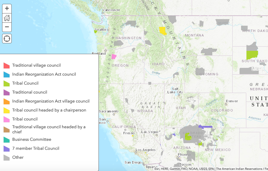 -Reservation system showing the types of governing body on the reservation.
I had a few minor issues with ArcGIS throughout the labs and I highly doubt that I could navigate the program without having the lessons in front of me, as many of the issues I had where typically ones I could not solve on my own. However, I did quite enjoy the process of working with HGIS which made my overall experience with this tool positive.
It is probably time to stop saying you are not tech savvy. I’ve taught professors with PhDs and lots of publications GIS and they run into the same issues. It all comes with practice. Try to remember that our culture goes out of its way to make some teenage kids feel tech savvy and convince others that they are not. Gender is central along with different learning styles when it comes to math. You sped through the lessons and managed to get ArcOnline working. I think you should start to accept that you might be more tech savvy than you think.