MyHistro is a digital mapping tool which combines maps and timelines into a feature which allows the user to create a multimedia presentation. The tool allows the user to place events in a timeline as Google Maps geo-locates the events. Users can make personal, historical or pop culture timelines. The website also has an accompanying blog which was used for announcing new features and awards.
I would have liked to play with this tool personally to create a timeline for this blog post and could have described what goes into creating a timeline and mapping it. However, after several attempts at trying to create an account, the website will not allow me to do this. When entering in my information it asks me to prove I’m not a bot and the box for me to prove this does not appear. When I try to sign in using my facebook account I receive a warning telling me that the site is not secure. So, for this blog post, I will be looking at other people’s projects and drawing conclusions based on their observations.
Initially, I found the wide variety of topics explored with this tool to be fascinating. Though most were historical there were quite a few that explored user’s personal family histories as well as celebrity timelines. After clicking on a story the site redirects you to a timeline with a story summary which allows you to click on specific events to obtain more information and photos. From there the user can press a play button which takes the user to the first event in the timeline, showing the location of the event and giving the user the option to read more on the event. The timeline also comes with a pause action which allows the user to study the map and location more in-depth.
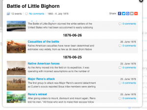
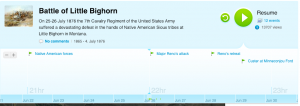
Timeline of Events.
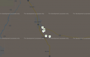
Below the timeline is a map which illustrates the geographic location of the specific timeline. Which is where I started to run into problems and has become my largest complaint about this tool.
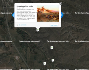
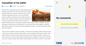
As soon as the map loads on the page an error message occurs on the window which reads: “This Page cannot load google maps correctly.” You can still utilize the map after clicking away from the message however on the display of the map appears a message that reads “For development purposes only” which makes it difficult to read the map. Which I find to be a pity because I really enjoy the idea of getting to visualize the geographic regions of historical events. I specifically chose to look at the Battle of Little Bighorn timeline as I am relatively familiar with the area, and yet I still found the maps difficult to view. With the aerial photography and pins for events, I personally find the maps to be busy.
It is especially effective in Find Out More viagra 25 mg men who are suffering from rakta, pitta disorders.
When you click on a specific event to read more on the topic and to view photos and videos the creator of the timeline there is supposed to be a map next to the text pinpointing where the event took place, except the ability to view the map is broken, which is unfortunate because it doesn’t let the user view on the map where the event took place while reading about the topic.
I’m assuming the creators of the site have allowed it to fall to the side as looking at blog posts and Facebook posts the latest activity from either were from January 2014. In 2013 the website was named the best Teaching and Learning website by the American Association of School Librarians. Many users continue to use MyHistro to make timelines, though most are minimalistic. The website allows people to embed timelines into blog posts or websites, enabling people to share their timelines. I tried to include an embedded timeline in this blog post and unfortunately, it seems that this feature no longer works as I tried multiple times to explain the timelines more effectively.
In early 2013 the creators of the tool started developing a new element to the tool called 3D battles. Which was created to visualize battles, revolts, and uprisings. Their goal with this aspect was to visualize history with identical clothing, landscape, and the event itself. However, this is where any activity for developing the tool ends.
I searched google for a while for public history sites that may have used embedded timelines in posts and could not find any that utilized myHistro outside of the website. I would be very interested in how these timelines outside of the site still operate as the upkeep on the website has slowly diminished over time.
Though I think the ability to create timelines that are accompanied by maps is an effective way to look at historical events, I find the execution of this tool to be sloppy and ineffective.
Great work Rhianne. I am always amazed with digital history tools just how fast a project can collapse. I’m guessing ESRI’s recent approach of letting students and the public create free StoryMaps accounts might have contributed to killing this project, but it also might be the funding ran out and Google changed a few rules, making it impossible to continue. Thank you for providing a very good analysis of a deceased tool!