Speaking the Language of Python

Python is a programming language that enables users to understand and manipulate strands of code. I have only had the chance to skim the surface of Python’s multifaceted structure and abilities with the help of Programming Historian’s “Introduction to Python” lessons. So far, I have followed through and completed lessons 1-6, and briefly glanced over the seventh lesson, “From HTML to List of Words (part 1).” I have found this lab complex with its easy-to-follow instructions but rather difficult concepts to wrap one’s head around. Having no previous experience with coding of any kind, I would say that these lessons have certainly opened doors for me in terms of grasping a deeper understanding of how the Web works, as well as looking towards skills to learn in the future.

The interest I have acquired in coding from Python fits well with one of Ian Milligan’s arguments in his paper entitled, “Lost in the Infinite Archive: The Promise and Pitfalls of Web Archives.” Milligan suggests that historians “…need to become aware of basic Web concepts: an understanding of what metadata is, how the Web works, what a hyperlink is, and basic definitional concepts such as URLs.” After going through the motions and gaining a sense of what Python is and what some of its abilities are, I have come to learn how the internet carries out certain tasks.

For instance, the first lesson explains how each web page is simply the end product of information or more specifically the language, HTML (Hyper Text Markup Language), that has been received and interpreted by the web browser. Any individual can view this language by right-clicking a web page and going to “View Page Source.” From there you can perform various tasks with that information using tools such as Python. For example, you could extract parts of a web page’s text to use elsewhere or download and open web pages. Another interesting fact that most individuals may not be aware of is shared in the fifth lesson “Downloading Web Pages with Python.” It mentions how web pages are files that are stored “on another computer, a machine known as a web server.” When you go to a web page you are requesting to see a specific file from the server. In turn, the server sends you a copy of that file, the web page that you end up viewing.

This knowledge may seem dull and insignificant but, like Milligan, I believe it is important that people are more aware of what exactly they are doing on the internet rather than use its services blindly. Perhaps if people learned more about how the internet worked, they would be more cautious of how they use it. Concerning historians, I also agree that it would be in their best interests to understand even the most basic aspects of the Web. In current times, information is more accessible but there is an increase in skepticism of whether the information that is being gathered and utilized is in fact true and substantial. If historians have the ability to further analyze the sources of their information, they may feel more confident with what they are applying to their overall research.

As for myself, I do not see the regular use of Python in my near future. However, I find its existence purposeful and, with the evolution and growth of technology, I may eventually require the knowledge of Python for later endeavors during my career. For now, I will leave Python and other computer programming languages to the computer scientists and engineers but encourage digital historians and other folks to dabble in them so they may broaden their horizons and continue pushing world history forward.

Mapping out the uses of ArcGIS

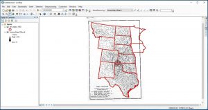
ArcGIS Map is a software that allows users to work with maps in a digital format and apply information to those maps so they may determine certain trends and answer various hypotheses. By navigating my way through lessons 1-3 from the Geospatial Historian website, I was able to learn how to apply data that was accumulated from the Great Plains of North America, centered around specific periods of time, onto a map of the area in question. I also learned how to “georeference” meaning imposing an image upon a map and getting the software to recognize each piece of media as one cohesive chunk of data (as shown below).


Doing this assisted me in both coming up with research questions that may have been missed if the work I was doing was conducted traditionally, as well as answering questions the lessons themselves posed. Throughout my process of working with ArcGIS Map, I have considered certain strengths and weaknesses that the software has in terms of being user-friendly and functional.

First, I will discuss the software’s downfalls. As I followed through the lessons, I realized how helpful the lessons themselves were when it came to simply familiarizing myself with the software. Without the step-by-step instructions, I may have become lost and confused earlier into the usage of the program. For the most part, the functions are displayed as icons rather than words. This made it more difficult to find certain functions that were not associated with a familiar symbol. For example, the button used to de-select data in the tables that were used, was shown as a puzzle piece looking icon. Without the clear notes of the lesson and its depiction of certain buttons, I would have either taken much longer to find the de-select button or would have missed it entirely.

Other problems were not as evident if you happened to not come across them. For instance, while attempting to click and drag certain items to rearrange the order of them in the Table of Contents, the action would occasionally not work. This was not a mere glitch in the system but rather a situation in which the program was picky. If you were not under the specific section of the Table of Contents entitled, “List by Drawing Order,” the program would not let you manipulate the layers of data. Although it is a minor problem, it easily became frustrating to me as a first-time user, before I had realized what was happening and learned how to resolve the situation.

Another small but inconveniencing dilemma I had faced while using ArcGIS Map was that the “Identify” function would not discontinue its use once you were done with it. If you are not familiar with this function it is a button labeled with a letter “I” with a circle around it, similar to what you would see at an information booth. This function allows the user to click on an area of a map and be notified about all metadata related to that area through the table of information attached to it. An example would be by clicked on a state or county and having a window pop up that provided the user with the name of the state or country they are addressing, along with other particular pieces of information. After I had clicked the “Identify” icon to use it, I could not get out of the function unless I chose another function to use subsequently.

Lastly, an extremely unfortunate concern with this software is its tendency to crash and shut down. An easy solution to this problem is to continuously save material and data as you alter it but this does not discount the fact that it’s an inconvenience and an annoyance. What I will say about this occurrence is that it is a reminder to users that GIS software is still evolving and, for the time being, the world of digital history still has room for improvements.

Overall, the program was reasonably easy to work with. Once I had completed the first two lessons, I found it easier to navigate and I gained a further understanding of what each function did and what tasks I could achieve through the software. The Table of Contents, where the layered sets of data were organized, made the program efficient and clean in appearance, avoiding the possibility of various components becoming muddled together. If I was using two or more sets of data collected in table form, they would be placed together in one window, similar to Excel, allowing me to toggle back and forth between data sets. This added towards the ease and organization of the program, giving it a more comfortable feeling for me as a new user. Even with the few minor details that need ironing out, ArcGIS is still a positive contributor to the world of digital history. It gives historians, geographers, and the like, the chance to advance their understandings of spatial events both past and present as well as visualize trends occurring over vast expanses of land.

The Wonders of HistoryPin: A Digital Tool

HistoryPin is a not-for-profit organization that provides cultural organizations with the means to expand on their projects and bring light to local stories around the world. It focuses on strengthening communities and bringing people together through collaborative work. It allows contextualization of historical information through visual mediums such as maps, videos, audio clips, and photos. Although it targets institutions that are already established as collectors of information such as libraries, museums, archives, and community groups who may need extra assistance in reaching broader audiences, it is also open to the general public. Many historical events are not recorded in professional archives but are kept alive through personal collections. HistoryPin provides people the opportunity to present those events in an organized fashion and preserve them so they may be seen by the world.

HistoryPin’s main goals are to produce, preserve, and share stories of a historical nature. The website is relatively user friendly and laid out in a logical sequence. The home page provides the user with both information about the tool itself (in text form and video guides) in case they are new to HistoryPin but it also encourages the user to immediately dive into using the digital tool. The user can either enter the area they are looking to find information on or simply peruse the collections that have already been created so they may gain a sense of what the tool does and how they can use it.

Starting on a personal project is incredibly easy to do on HistoryPin for various reasons. First, it is free to use so no matter the size or scope of the project, it can still be done in an efficient and presentable way regardless of the individual’s budget. The organization is transparent to its users, meaning it gives full disclosure on who its members are, what services/abilities it provides, and what its policy is in regard to using user’s personal information. Member’s contact information is given on the Team page and anyone can voice a concern or question to the website faculty through the FAQ page. All of these aspects give users good reason to utilize the digital tool but also gives them freedom to choose whether it is the platform they want to use or not without strong-arming them into paying any kind of fee.

So, what can HistoryPin do exactly? It allows users to create their own type of archive or “collection” as they call it on the website. By starting a collection, items must be “pinned” to maps. These can include photos (from public domain, original works, or if permission has been given to share it), videos (original or embedded from other sites such as YouTube or Vimeo), audio clips, or simple text. Each pinned item should be given a name, a location, and a license for possible further use as people can pin each other’s items. This is a great feature because it gives users many options to customize their collections and it also ensures that each item is accompanied with enough metadata to give it context. Though each item is pinned to a place of origin or residence on a map, the website enables the ability to hide the map or display it. This way, those who are simply observing collections have the option to either focus on each item alone or be able to see where it came from. To give perspective, photos can be imposed over present day street-views from Google Maps.

Other positive aspects of HistoryPin include the ability to collaborate with others, embed, edit or delete content, and upload groups of items rather than individually. Once a collection is made, it can be managed by numerous individuals. The original creator can add others as co-managers so that they also may contribute or edit the collection. People from outside of the collection can also add pins to collections they do not own, giving the tool an interactive and community-based environment. People can also transfer embedded items to other websites such as blogs, which can increase the attention their collection acquires. This means that if someone were to embed another item elsewhere on the internet, that item is still attributed to the owner by directing whomever clicks on it back to HistoryPin. Accounts can be edited or deleted as well as collections or single pins, giving curators full autonomy over their collections. Lastly, items to be pinned can be uploaded in groups with the Bulk Uploader page. It is compatible with both PC and Mac which is incredibly convenient to all users and helps make their experience with HistoryPin a more time efficient and positive one.

Although it has many positive characteristics, HistoryPin also has a few downfalls. For instance, due to the crowd-sourcing nature of the tool, some collections are incomplete because no one has contributed to them. Some pins also do not work; whether that is an issue with the website or how the creator linked the pin is unclear. Some maps are incredibly cluttered, depending on what the collection is of and how much material was found for it. This can make pin selections difficult if someone were to sift through them. Even though items can be embedded into other sites and traced back to their source, there is no way to tell if the user has the appropriate rights to that material.

Overall HistoryPin is an enjoyable digital tool to use when archiving digital resources and telling local stories that may not otherwise be known. It provides many opportunities to share small projects through social media and other websites, helping catch the attention of numerous people. It is a perfect tool for those who learn visually and want to put a unique spin on upcoming digital projects people may be looking at creating. If you want to create a visually appealing and incredibly interactive archive or digital collection, complete with a mapping component, HistoryPin is the digital tool for you.

Regarding Richard…

Richard Pryor’s Peoria is a digital archive that was created by Scott Saul, a professor from the University of California, Berkeley. Scott had written and published a biography on Richard called Becoming Richard Pryor. Having collaborated with other scholars, Scott collected the archival materials he had used in the creation of that work, including oral accounts of those from Richard’s hometown who had personally known him, and placed them in this digital medium. This digital archive is part of a bigger project called The Spatial History Project. Its purpose is to bring awareness to the growing uses and possibilities of digital histories that are becoming more prominent in the world of humanities. Although this is Scott’s specific goal, his project provides the public with other important uses.

Scott’s project, Richard Pryor’s Peoria, gives a clear sense of what digital histories can do and how they work. It can be considered a template so that others who are interested in creating their own digital history projects may know where to start and what to consider while planning themselves. The website itself is incredibly user friendly and visually appealing. The colour scheme suits the topic of focus and Scott utilized many different features that make the project interactive and easy to navigate through. Under the “People” tab, you can either click on it directly and come to an overview of the people who were the most influential toward Richard, accompanied with a simple social network analysis, or you can select one of the individuals under that category and be directed to a case study on each person. The same goes for the other three categories, although the overviews are supplemented with components that suit that topic, such as a timeline for the “Eras” tab and map for the “Places” tab.

In addition to providing guidance on the creation of digital collections, Scott’s project also provides individuals with a useful archive for further research on an assortment of topics. Since the collection not only focusses on Richard Pryor, but Peoria, Illinois, and events which had occurred throughout the 1940s and 1950s, individuals looking for information surrounding those places, times and events can use Scott’s information for their own purposes. Richard lived when segregation was still common, crime was committed openly, people were pushing for human rights, and the world was at war for the second time. Scott not only describes how each of those circumstances affected Richard as he grew up; he also addresses them as stand-alone subjects that can be addressed individually. This allows the public to educate itself on one of many unknown places in the world and realize how global affairs affect every corner of the planet.

While being relatively thorough in the presentation of his information, Scott’s project also has some downfalls regarding its overall purpose and the way he went about obtaining information on Richard and the town of Peoria. As interesting and engaging as Scott’s project is, its target audience is limited to a small group of people who may be interested in information about Richard Pryor and where he grew up. This indicates that only few will visit the website or even know of its existence. For Scott, this may be fine since it is only a small project and is not in need of a large audience. On the other hand, how effective is Scott’s project if it only reaches a small handful of individuals? Richard Pryor’s Peoria only covers small details of larger events. If anyone were to try and start their research with this website, say on World War II for instance, they would not get very far and may not even know where to start elsewhere. With regards to Richard himself, the same case could be made. Scott has a decent collection of information on Richard and those who lived with him, but in general, information is still limited. This begs the question, did Scott use everything he possibly could find on each person and event or did he systematically simplify it? The project is, after all, a companion to the written biography he created beforehand.

One other weakness the project is prone to is the type of materials Scott used for his research. In the “About the Site” section of the project, Scott mentions his use of in-person interviews with people who knew Richard personally. Oral histories can be very helpful in bringing light to certain subjects that could be overlooked or not even mentioned in written documents. Unfortunately, they can also distort facts and lead the researcher into uncertain territory. Personal memories can be unreliable and the use of oral histories can lead the researcher into being susceptible to lies and biases. Even if Scott was aware of these concerns while researching, there is no way for him to be sure that the information he received from his interviews was completely correct since not all information can be fact checked.

As a whole, Scott’s digital project Richard Pryor’s Peoria, is well put together. It is clear that Scott took part in extensive research on Richard Pryor and Richard’s hometown. It is unclear how long the project took to complete but it would be fair to say that Scott and his team worked on this project long enough to provide the public with a smoothly operating and appealing website which is filled with fascinating and thought-provoking material. Though the project will only catch the attention of a small number of viewers and is possibly limited in factual information, it succeeds in exemplifying what a digital history project can look like and what it can do. Richard Pryor was a significant man who existed during a significant era and Scott Saul tastefully placed him back in the spotlight, furthering both digital histories and an awareness of what Richard had experienced throughout his time here on Earth.

This is me

Hello, my name is Dakota. I moved around quite a bit as a child so I do not have a hometown of sorts. I am 23 years old and on my way to finishing a History degree. History was my fourth career choice as I was unsure of what to get into straight out of high school. I started with a major in Animal Bioscience then jumped into trade school, enrolling myself in an Automotive Technician course. After realizing trades were not for me, I came back to University and applied for Agriculture business. The business side of that degree did not agree with me so I finally landed on History, deciding that something I enjoyed learning was much more worth my time and money as opposed to something that everyone else was doing or what I thought would give me a great future. I hope to gain tons of knowledge from this course and hopefully it will assist me in future endeavors once my schooling is finally complete!